Poker Creek Avalanche Fatality
Salt River Range, Wyoming; February 23, 2023
Avalanche Comments
On Thursday, February 23, 2023, at approximately 12:15, a snowmobiler unintentionally triggered an avalanche on a mid-elevation (8020’), west-northwest facing slope below tree-line one half mile north of the Poker Flats Safety Shelter (42.5236, -110.7626). It was a small avalanche and medium-sized relative to the path. The avalanche broke on a layer of faceted snow crystals above a thin crust buried on January 26th. This avalanche was triggered at a thin spot in the snowpack created by wind scouring due to variable wind directions over the course of the season. The slope above the trigger-point was loaded with drifted snow, primarily from a southerly wind direction, in the days prior to the accident. The avalanche broke 75 feet wide with a maximum crown height of 30 inches and average height of 20” with a vertical fall of just 50 feet (HS-AM(u)-R3-D1.5). The slope where the avalanche occurred terminated into a streambed located at its base. This avalanche was one of only two avalanches on a northwest aspect of the 81 avalanches observed or reported across all forecast zones in the 30 days prior to this incident. A preliminary analysis video of the accident can be found here.
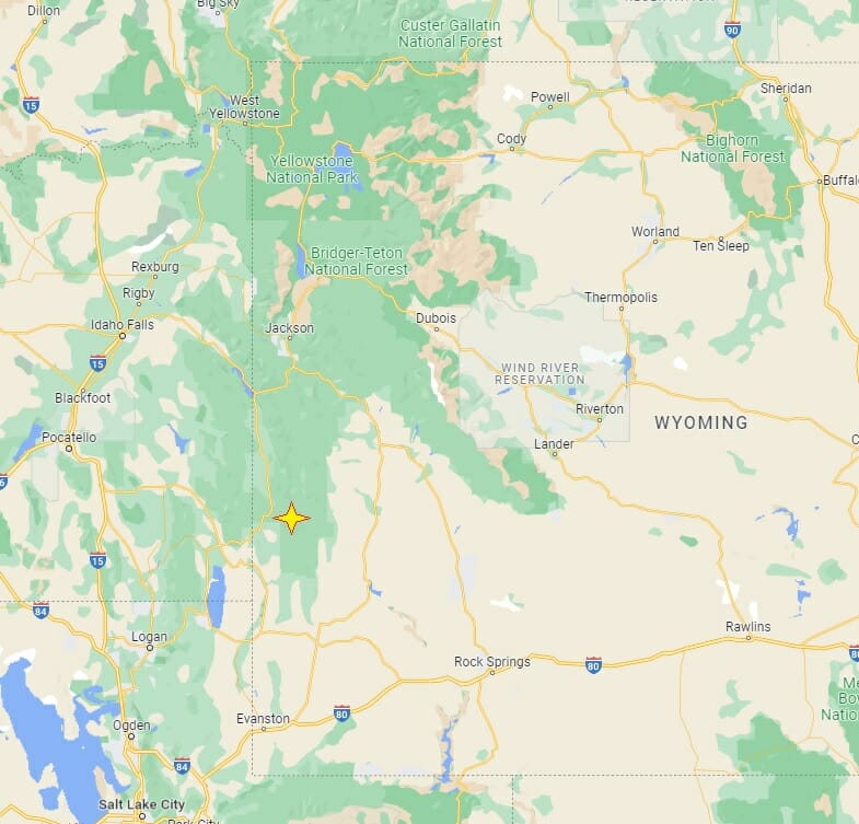
Figure 1 The incident site is 12 miles via groomed snowmobile trail from the Smiths Fork parking area, located 15 miles south of Afton, Wyoming.
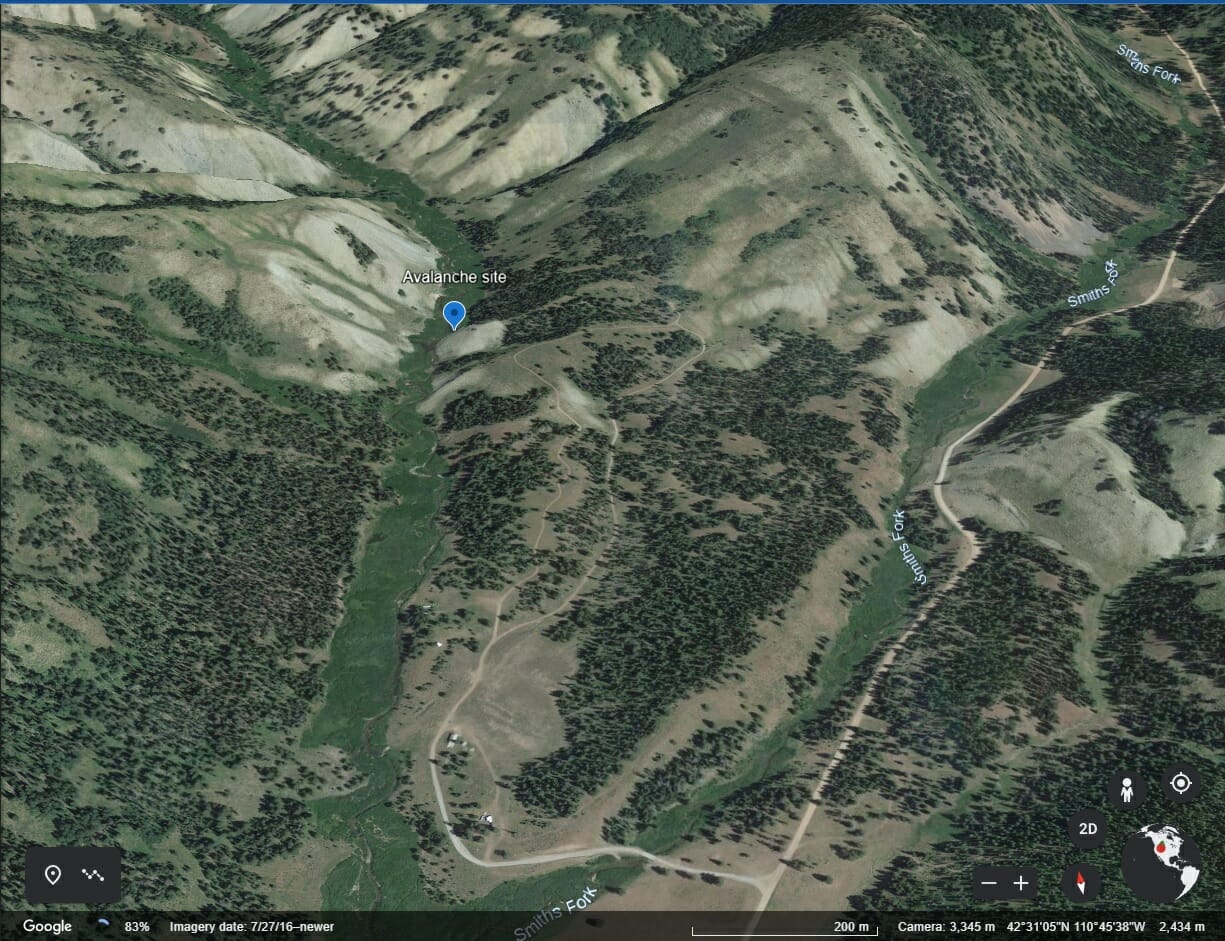
Figure 2 The site of the avalanche was on a small knoll on the east side of Poker Creek.
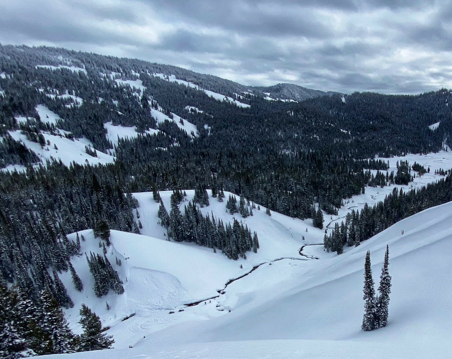
Figure 3 Looking down on the site of the incident from the west.
Backcountry Avalanche Forecast
The Bridger-Teton Avalanche Center forecast on February 23, 2023, rated the avalanche danger in the Greys River zone at Considerable above 9,000’ and Moderate below 9,000’ where the incident occurred. Wind slab avalanches were highlighted as the primary avalanche problem on all aspects above 7,500’ with persistent slabs highlighted on all elevations and aspects except SE, S and SW lower elevation slopes. The expected size of wind slabs was small to large (D1-2.5) and likely. Persistent slab avalanches were listed as possible, ranging from small to very large or D1.5 to D3. The Bottom Line section of the day’s forecast stated:
At elevations above 9,000′, triggering a large avalanche remains likely on steep, wind loaded slopes. Many lower elevation areas also contain wind drifted slopes, as well as 1′ to 2′ thick slabs of storm snow that sit on top of weak snow. It is possible to trigger an avalanche large enough to bury a person on steep slopes even near valley bottoms. Evaluate the snowpack and terrain carefully for wind drifts, shooting cracks in the snow surface or sounds like whoompfing that indicate weak layers in the snowpack.
Weather and Snowpack Summary
Several weak layers formed over the course of the season. This avalanche failed on a crust with facets above and below which formed during high pressure and was buried on Januarys 24 – 26. The following excerpt from the Snowpack Summary product published the prior week summarizes the snowpack situation until the time that the storm impacted the area Feb 18th to the 21st.
In the prior week…”no persistent slab activity was reported, and snow pit stability tests have shown these layers are becoming less reactive. There are still slopes where you can find propagation on W-S-E aspects in middle and upper elevations. One pit dug on Feb 13th resulted in ECTP18 on an E aspect at 8700’ on a wind loaded slope that failed on the Jan 26th facet/crust layer. This next heavy storm cycle could change the reactivity of this layer, so careful assessment will be necessary as these layers become stressed with the loading of new snow. Snow surfaces will also play a role in this incoming storm, with a mixture of hard wind pack, crusts, and near surface facets.
The storm that impacted the area prior to this incident brought 24” of snow and 2.15” SWE (Snow Water Equivalent) to Commissary Ridge weather station located 3.5 miles to the northeast at 9,330’. Avalanche danger increased to High and Considerable at lower and middle elevations during the event due to new snow stressing weak snow layers at lower elevations. While the January 26th layer had not produced avalanches in the previous 3 weeks, the near surface facets closer to the surface produced widespread, small to medium sized avalanches at lower and middle elevations. The forecast on the day of the incident described the persistent slab avalanche problem that remained a concern as follows:
A significant slab was added to locations that hold weak snow, particularly at lower elevations. Many avalanches were observed or triggered yesterday indicating the sensitivity of buried weak layers. Triggering an avalanche will be most likely on weak snow recently buried within the top 1-3 feet of the snowpack. The drought conditions and cold clear nights prior to the most recent storm resulted in widespread facet growth near the surface. While not the weakest of weak snow grains, they are not to be trusted. Perform stability tests near your intended line and consider terrain factors that could create problems like convexities, buried rocks or slope angles over 35 degrees.
Low-elevation slopes have very weak snow. Any slope steep enough to slide, regardless of elevation, should be assessed carefully. Conditions remain sensitive, especially in wind loaded areas where slabs are thickest. So far, upper elevation avalanches on the more deeply buried persistent layer (Jan 26th layer) have not been observed and it’s possible that these locations with a much deeper snowpack over the buried weak layers will remain dormant.
This avalanche broke on the January 26th layer which consisted of small (.5mm) near surface facets on a friable, knife hard, 1 cm thick crust. (Figures 9 and 10) The last reported avalanche to fail on that crust/facet layer in the BTAC forecast zones occurred on Mt Taylor on January 30th. Further, similar reported avalanches are exceedingly rare with only 3 of 174 avalanches this season occurring on a northwest aspect.
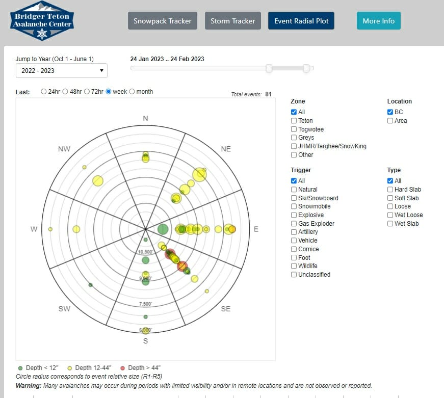
Figure 4 This radial plot of avalanche activity shows a dearth of events in the northwest aspect in the month prior.
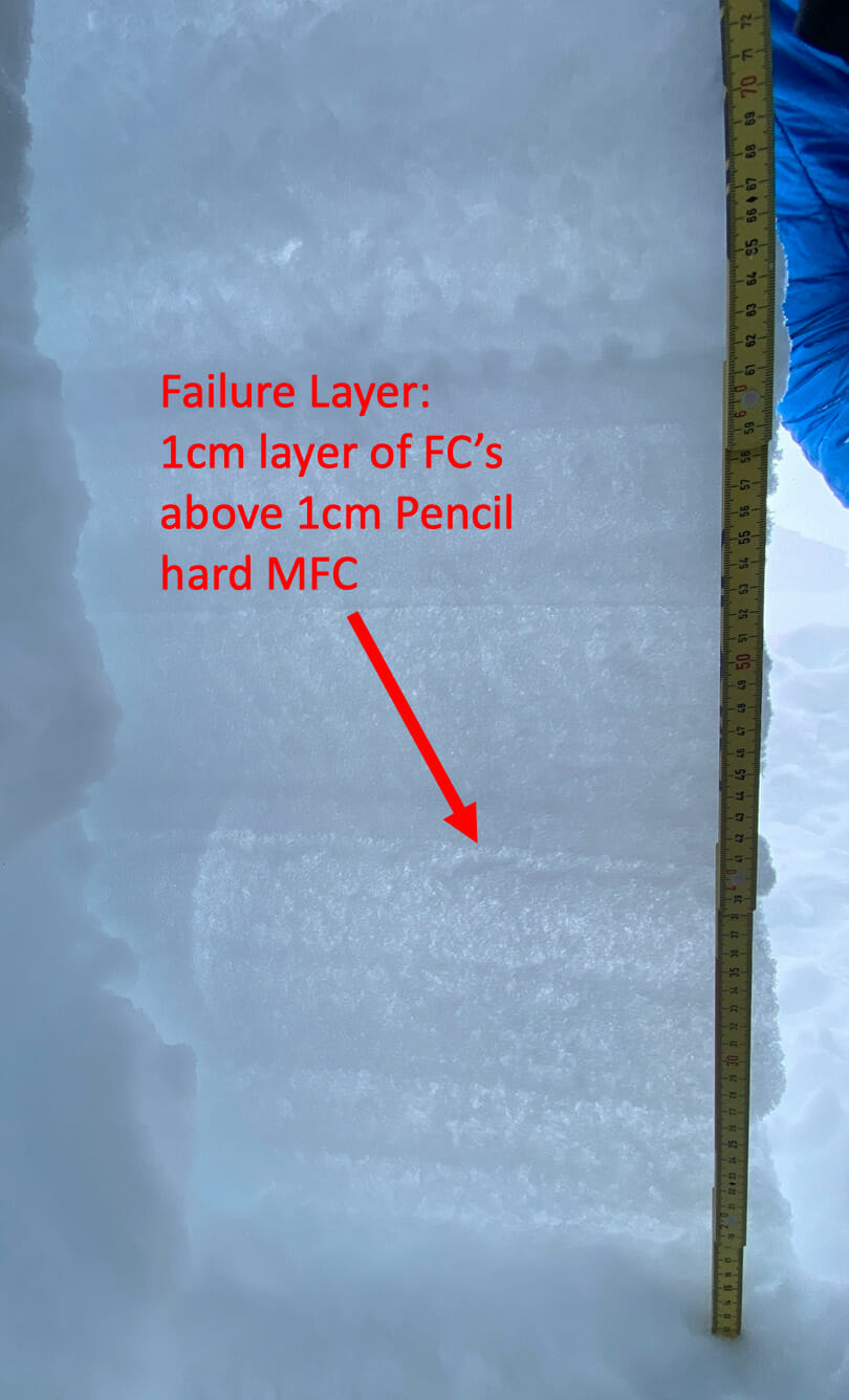
Figure 5 Cross section of snowpack at the crown.
Accident Summary
A group of five riders departed from the Smith Fork parking lot that morning. The group entered the upper reaches of the Poker Creek drainage from an area known as the Terraces. The group then separated with the intention of meeting at the Poker Flats Warming Shelter for lunch. Two of the riders continued on through simpler terrain to ride trails while the other three riders played on features in the wide drainage and adjacent slopes. The three were making their way slowly down the valley. Rider three lagged behind the other two after a re-entry trick did not go as planned. Riders one and two approached the incident slope approximately 75 yards apart with rider three catching up. Rider One began to sidehill across the slope near its base (Figure 5) from the north. Rider Two witnessed Rider One’s sled “washing out” or turning uphill while Rider three witnessed the airbag deploy. Rider 1 then disappeared from view.
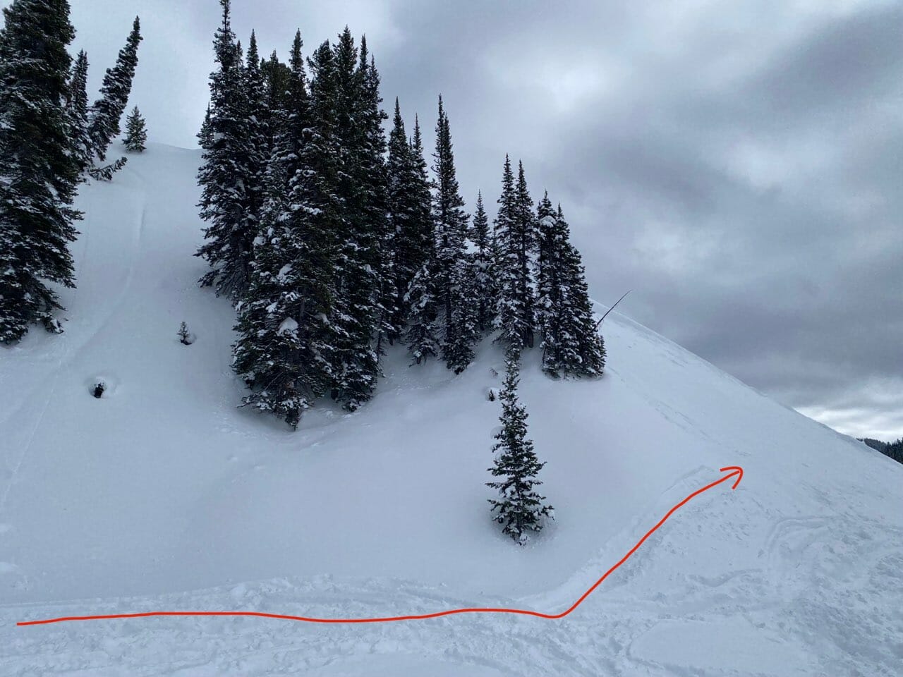
Figure 6 The route followed onto the slope.
Rescue Summary
Rider Three throttled hard towards the scene, jumped the stream on the edge of the debris on his sled and began a beacon search on foot. Rider Two joined him with a probe and shovel. Rider Three obtained a transceiver signal and struggled to reduce the distance in the deep debris which was a mix of hard and soft debris. He quickly acquired a distance of 11 meters with no sign or clues on the surface of the debris field. The two searchers were initially confused by the lowest numbers displayed on their beacons in the two to three meter range before realizing this was a deep burial situation. Rider Three acquired the lowest reading of 1.8 meters (6 feet) while rider two began probing. After several probe strikes on the rocky streambed, the pair probed Rider One and confirmed with each other that this was their companion. They dug quickly but soon struggled to clear snow as the hole grew in depth.
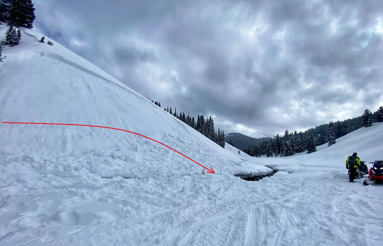
Figure 7 The trajectory of the rider across the hill and into the creek bed as the slope failed beneath his sled.
Rider Three stopped digging briefly to radio for assistance from the other two members of the initial group of five. One of those two proceeded to the scene while the other used the base station radio located at the Poker Flats Warming Hut to call for help. Lincoln County 911 Dispatch received the call and dispatched Star Valley SAR at approximately 13:07.
The three at the scene continued to dig and reached Rider One’s airbag after approximately 30 minutes of digging. They continued to dig towards the rider’s helmeted head which was oriented face down in dry snow. Rider Three checked for a carotid pulse but found none. The group, who was now standing in wet slush from the avalanche debris dammed stream, continued digging and found that Rider One’s legs were pinned under his sled. They were unable to free him and continued to excavate around the sled which was also buried under 6-7 feet of snow.
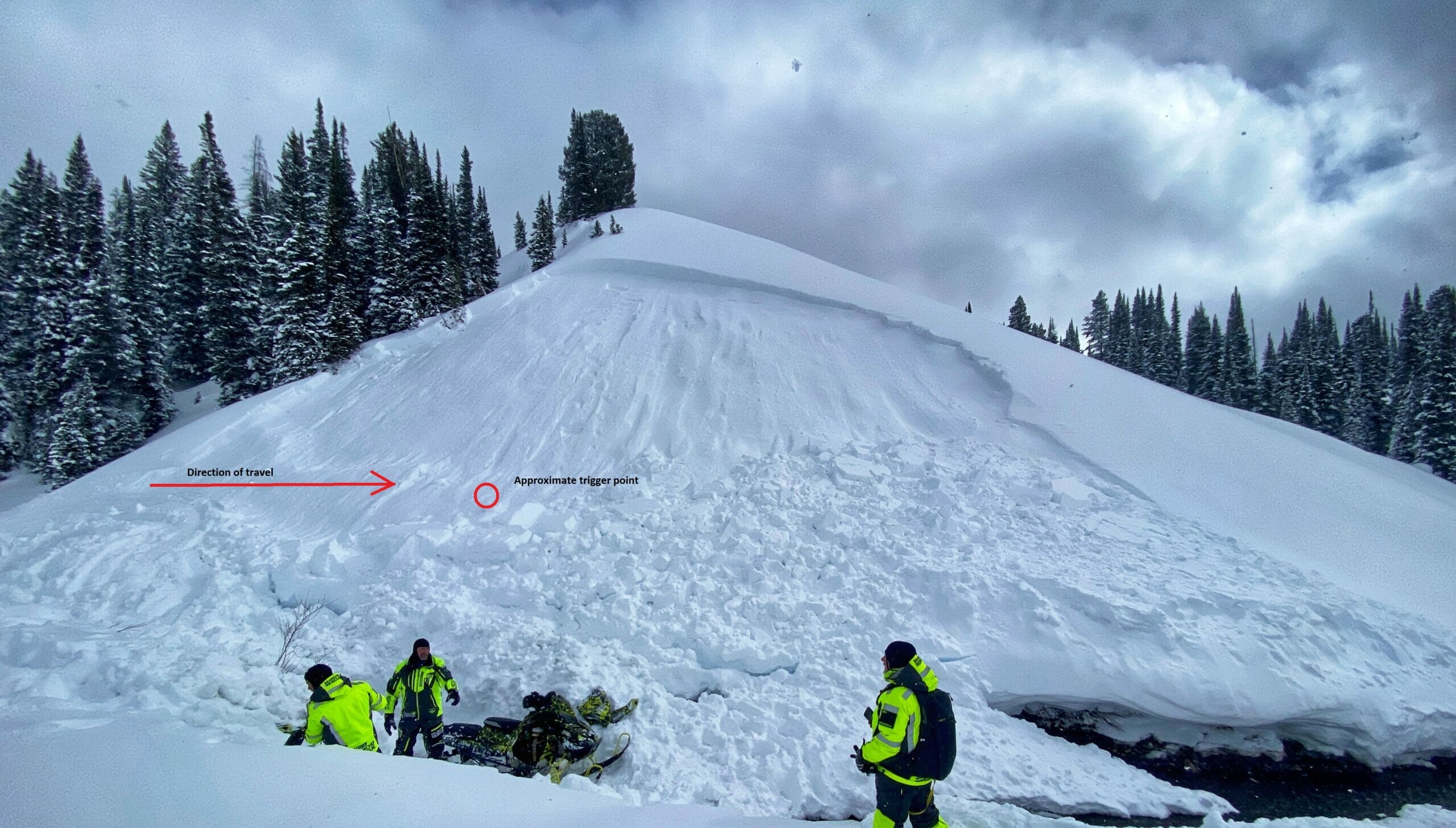
Figure 8 Rescuers recover the sled from the scene the day after the incident.
At 14:37, Star Valley SAR reached the scene and assisted in the digging, ultimately digging around the sled entirely to lift it enough to free Rider One’s legs. The recovery was completed with Star Valley SAR clearing the scene at 17:09 after transporting the deceased to the Smith Fork Trailhead.
Comments
All of the fatal avalanche accidents we investigate are tragic events. We do our best to describe each accident to help the people involved, and the community as a whole to better understand them. We offer the following comments in the hope that they will help people better understand and possibly avoid future avalanche accidents.
All members of the group were highly experienced, expert snowmobilers with a very high skill set and spent prolonged periods of time riding in the area. All had undergone a formal, Level 1 Avalanche Course and some had taken a one-day mechanized avalanche workshop. All members of the group were appropriately equipped with suitable avalanche rescue equipment including airbags as well as radios and had the training to use this equipment. The group also knew how to summon outside help with the radio equipment located in the warming shelter and called for outside help at the right time.
In many avalanche accidents, there are obvious human factors that lead to bad outcomes. These incidents make it easier to learn but perhaps easier to pretend we won’t make the same mistakes. This is not one of those incidents with obvious mistakes. This group had not seen signs of instability since the storm had cleared two days prior nor were there any other avalanches that day despite heavy use during vacation week. This group read the forecast daily and they were aware of the persistent slab avalanche problem but also knew that triggering that type of avalanche was unlikely in the current conditions.
Recreating in avalanche terrain means assuming some level of risk on a daily basis. Risks present themselves each and every time we enter mountains with snow covered slopes. This group did a lot of things to maintain a safe margin and to be prepared for accidents, including avalanche accidents. The following are a few ideas that could be applied to increase safety margins while riding.
Rider One’s view of the slope that failed was limited by a stand of trees blocking the true slope angle along with what may have been subtle signs of wind-loading. An assessment of the slope from another angle may have given some indication of the steeper, 40-degree slope above the 30-degree toe of the slope. Another vantage point might have revealed the subtle signs of wind loading.
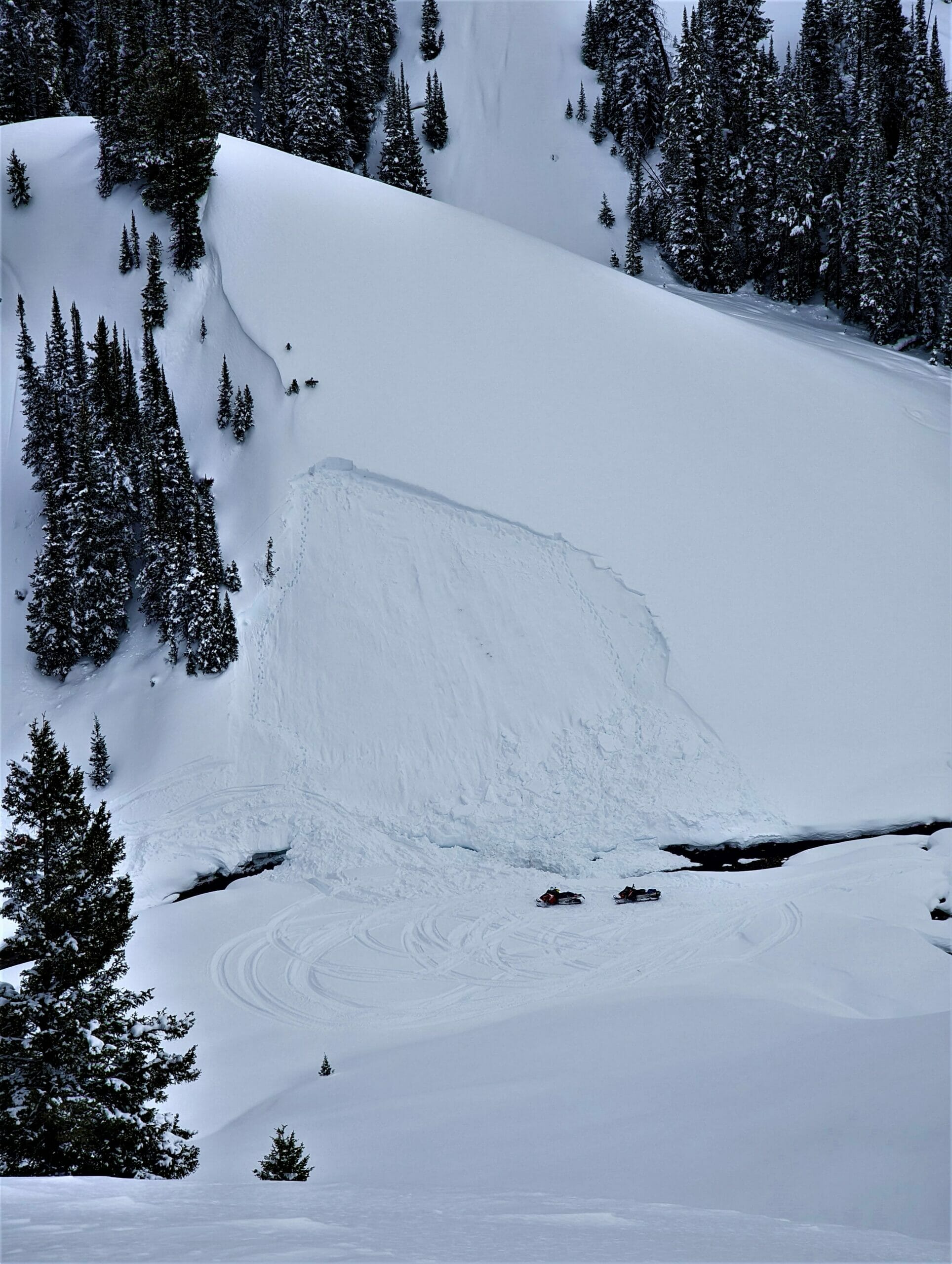
Figure 9 Overhead view. Note the patch of trees which obscured the view of the steeper and wind loaded portion of the slope.
When traveling in avalanche terrain, advanced riders often take on elevated levels of risk while on slopes above terrains traps like gullies, streambeds, or trees. Any terrain feature that causes an accumulation of debris can lead to an unsurvivable avalanche burial even with an airbag deployment and relatively rapid recovery. When there is any question of stability on a slope above a terrain trap, snowpack assessment becomes critical. Dig a pit or perform slope tests in a safer location to check for the presence of buried weak layers. This slope contained a thin snowpack at this elevation due to terrain driven winds which had recently deposited dense snow that stressed the buried weak layers. A quick pit may have revealed the presence of two weak layers close enough to the surface to be triggered.
BTAC staff are grateful for the open information sharing by the party involved. Sharing experiences like this openly is difficult but critical to creating an opportunity for the community to better understand and learn from these tragedies. Our sincere condolences to family, friends and other’s impacted by this loss of life.
(Note that two important details regarding the rescue emerged following initial reports. The deceased was buried deeply but was not facedown in the water. Dry snow separated the buried man up until about the time that his friends dug to his head. Also, the deceased’s two companions dug to their friend’s head in about 30 minutes, not an hour and a half as previously report. That reported time was the amount needed for the rescue team to assist in excavating and lifting the sled from the deceased man’s legs in order to free him.)
Investigation and report by Frank Carus, with assistance from Mike Austin and BTAC and BTAC Foundation staff
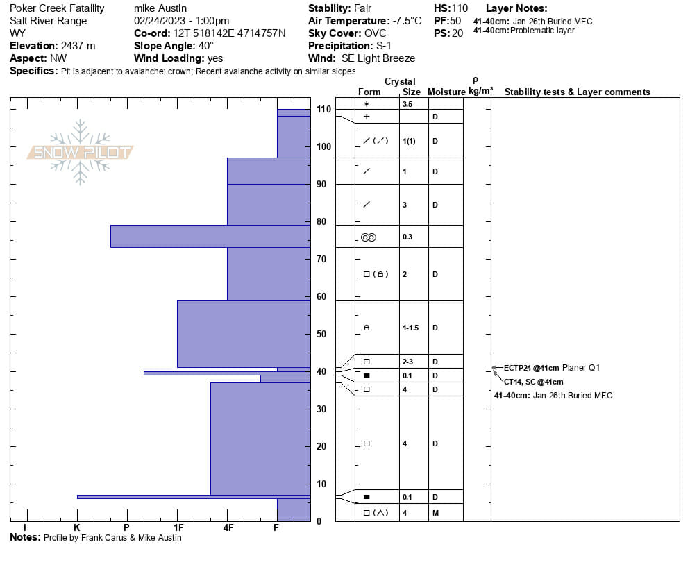
Figure 10 Snow profile taken at the maximum height of the crown. Note that total height of snow is just 110cm here.